In recent years there have been many theories and speculations about
Tartaria, a toponym frequently found on Western maps of past centuries. This topic has been actively picked up by newagers, trying to materialise the atmospheric electricity of ancient Tartaria. The theme has also been supported by many nationalists, relying on the Aryan root in the word Tart-aria (which can be seen as a bit ironic, as in modern English the word "tart" has the meaning "sour, irritable, sarcastic" in adjective form and "pie, prostitute" in noun form). On
"Tartar Architecture" as a new conspiracy theory was recently written about by Bloomberg. The current position of academic history on the matter is that the word "Tartaria" meant a territory, a mythical country, but not any state or empire of the past. Perhaps in this matter, in order to get the most accurate idea of the past, it is worth relying not on modern opinions, but on the opinions of the contemporaries of Tartary itself.
It is worth noting that for a long time in the Russian language when translating Western books
"Tartaria" was translated as "Tataria" and, accordingly, "Tartars" as "Tatars". I suggest reading the description of Tataria from the geographical reference book
Thesaurus Geographicus of the English-Dutch cartographer, engraver and publicist
Herman Moll, published, as stated, more than 300 years ago:
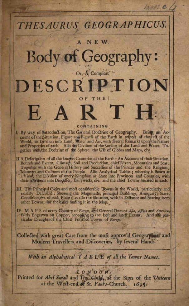
TARTARY, TARTARIA
This vast Country is not sufficiently known, to give an exact Relation of it; except it be of those parts which border upon Muscovy, Persia, the Empire of the Mogul, and the Northern parts of China. And the Cause why it hath not been as fully discover'd as other Nations, is the great Difficulty of getting into it, because of the great number of High Mountains, horrible Deserts which encompass it, Rocks and Banks which run all along the Eastern Coasts, and the continual Ice which is upon the Shorts in the North.
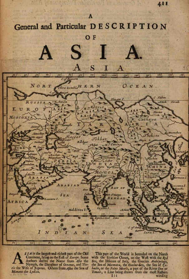
Tartary, which is more than a third part of Asia, takes its Name from Tartar, or Tatar, a River in the Northern Parts. It is called the Great, to distinguish it from the Less, which is in Europe, and joins to Turkie. The Ancients called a great part of it Scythia Asiatica.
This large Country is bounded on the North with the Frozen Sea, on the West with the Caspian Sea and the Country of the Great Duke of Muscovia, on the South with Persia, the Indies and China on the East, with the Sea of the Kaimachites, and Streights of Jesso or Uriez. The Extent of it from South to North is about 640 Leagues, from the Confines of Sablestan and Chorosan near Mount Taurus, to the Cape's End, towards Nova Zembla in the Country of the Samoiedes, between the 34th Degree and 71st Degree of Latitude, and from East to West about 2000 Leagues, from the Streights of Casa to that of Jesso, between the 68th and 197th Degrees of Longitude, comprehending that part which is under the Muscovite, and in its largest Extent.
The Air of this Country is different, according to the several parts of it, which are vastly distant one from another. It is so very rough in the Northern parts, that the violent Winds which sometimes blow there beat down Men, overturn Walls and Trees, and the Seas are all over Ice. The Land also is very barren there, and full of Marshes and Rocky Mountains. The South parts are of a clear different Nature, producing Rice, Hemp, and Rhubarb in abundance; as also, Wool, Silk, Cotton and Musk. It feeds also many Horses and Camels; and towards the North there are White Bears, Black Foxes, Ermins, and Sables, which are the principal Merchandize of the Country. They have great Numbers of Pheasants, and several other kinds of Birds. The great number of Mountains, Forests, Marshes, and Desarts full of Sand, make a great part of the Country not habitable, and unfit for Tillage.
The most remarkable Rivers of Tartary, are, 1. The Oby, which riseth in Ostiaski, and passeth cross Grustinski, the Country of the Sameiedes, and empties it self into the Northern Ocean, having received into it the River Irtiske, a little below the City Toboul, which comes out of Taista Kalmuck on the South-East of the City Bulagan, where it crosses the little Lake Kisubas, and then goes through the Prince-dome of Ablay, and through Sibary. It's whole Course is about 1000 Leagues from East to West, and then from North to South. It receives on the right side the Rivers Bescha on the Confines of the Princedoms of Kol and Ablay, Henkutia below the City Loukaragay. On the left it receives the River Toboul, a little below the City of the same Name; and several other smaller Rivers on each side. 2. Tongusi hath its Original in the Southern Tartaria Moscovitica; it's Course from South-East to North-East is more than 800 Leagues. Near the City Ilimsko it receives the River Ilima, which divides it self into two parts in the Country of Jacuti, of which the the Northern part keeps its Name to the Sea; but the other is called Len. Tongusi receives the River Jenica on the Left side, and then empries it self into the Frozen-Sea. 3. Amor rises in the Country of Daouri; the Course of it from North-East to South-East is about 500 Leagues. It receives the River Skilka on the right side, a little below Albasin, and then falls into the Sea of Japon. 4. Two Rivers, that lose themselves in the Lake Baikala: One, which comes from the Confines of Brast-ka and Jacuti, runs from North-East to South-East above 300 Leagues; and the other, which riseth within 9 or 10 Leagues of the City Jaranava, runs from South to the North-East about 250 Lagues. 5. Joxartes rises in Usbech Giagatay in the East, and runs from East to West into the Sea of Kulsum, or Caspian-Sea; but in the way receives Alsogd, Ardock, and Oxus on the left side: It's Course is 500 Leagues. 6. Rudha joyns it self with the River Yem, and having passed the two Countries of Kolmak, run both into the Caspian Sea at the Gulph of Mingus or Jave. 7. Uppa riseth out of Pascatir, and crossing Casan, empties it self into the Volga. There are several other Rivers of less note in this Country.
The principal Lakes are, 1. The Lake of Marsan in the Country of Kolmak toward the West. 2. Kisulbas in the South in the Princedom of Kol. 3. Thama. 4. Parvan in Tongugi. 5. Baikala in Daouri. 6. Chiamai in the Kingdom of Lassa, out of which rise four or five great Rivers, which run into the Indian-Sea. 7. Taus, in the Country of the Samoiede.
There are also long Ridges of Mountains, viz. of Hithay, Cocaya, Bengiar, Farvan, Saina, Magoa, Caucasus, Thibet, and Centava.
The Tartars are naturally savage, treacherous and cruel, especially in War, in which they often devour their Enemies, drinking their blood, and eating their Flesh, to make their Hatred irreconcilable. Their ordinary Food is Rice and Milk. When their Cham dies, they kill and interr with him many of his Chief Officers, that they may attend upon him in the other World, and give him enough to maintain him according to his Greatness and Quality.
Two third parts of this vast Region are Idolaters, especially towards the North; there are many Mahometans in the South. Some Countries there are in the Northern parts, where the People have no manner of Religion. Near the Caspian-Sea there are some ancient Jews and some Nestorians. There are very few or no Catholicks among them.
The Language of the Tartars is understood in most parts of the North, and in some of the East. It is something like the Turkish Language. Soldiers are there innumerable, and the Lords of the Tartars send their Emperours in times of War an 100000 Horse. Their Forces consist in the multitude of Soldiers, who are always ready for any Service, to pass Rivers in obedience to their Commanders, to endure any Labour in marching towards their Enemy, or retreating from them, as occasion requires. They will shoot their Arrows very exactly at their Enemies, while they seem to fly from them; and all on a suddain will face about upon them to give a Charge, without Disorder. They will compass their Enemies in on all sides, and not mingle with them.
Their Women only buy and sell for the most part, the Men being employed in Hunting and Fighting. They have the best Hawks and Hounds in the World. They live for the most part in the open Field, as the Arabians do, in Tents, in which also they keep their Cattel with them. They are almost all Horsemen. When the Summer begins to approach, they go into the Northern parts, where there is more Cold; and when Cold becomes great, they retire into the South into some hotter Country. They conduct their Familiss by small Journics, and carry their Houses in Carts covered with Skins, wherein they put their Wives and Children, and their Houshold-Stuff. They provide themselves in several places Ox and Horse-dung, and a sort of Stones for firing. Their Thunder is very dreadful, and Winds very violent, which take their Soldiers off from their Horses, and pluck Trees up by the Roots, be they never so deep in the Ground.
The Great Cham hath the Tenth part of the Wool, Silk, Hemp, and all other Commodities of his Empire. Every one of his Subjects is also obliged to work one Day in the Week for him, or do him some other Service, according to his Quality. He hath two Councils, made up of 12 of the wisest and experienced Men, of which one always attends upon the Affairs of State, and the other of War. Their Riches consist chiefly in Cattel, Horses, Furrs, Honey, and Wax, of which they have prodigious Quantities. This vast Country is governed by several Princes, Kings and People, besides the Emperor, who is called their Great Cham, to whom several Kings are Tributary. The Lives and Estates of all his Subjects are in his power to dispose of them as he pleaseth. No man may speak to him but upon his Knees, giving him a kind of Adoration, which is likewise observed by all Embassadors, who speak to him only by an Interpreter. Emperour at this day rules over almost one half of Asia, espeially since he hath made himself Master of China, and several other States.
Some divide the Great Tartary into five parts, which are, 1. Tartaria Propria. 2. Tartaria Deserta. 3. Zegathay. 4. Cathay, and 5. Lurguestan. But this Division gives us a very confused and imperfect Idea, or apprehension of it. The best Division, and most conformable to the Relations of our late Travellerss thither, is into 25 Parts, as in the Table.
These Countries some call the Muscovian Tartary, or Tartaria Muscovitica.
1. Part of the Kingdom of Casan, in which are: Casan, Kibena.
2. Part of the Kingdom of Bolgar, which hath: Bolgar, and Samara.
3. Part of the Kingdom of Astracan: Astracan, Batrach.
4. Pascatir, or Besegeret.
5. Siberie, in which is Toboul.
6. Samoiede, a People who have: Kakinscoya. Pohem.
7. Grussirisri, which contains: Clarem. Jurgue.
8. Ostiaki, a People who have: Makouski. Choroda.
9. Tongusi, or Tingoeses, a People, among which are: Jenisca. Ilimsko.
10. Bratskra, a People which have Bratskra.
11. Jakuti, a People which have Jukustanke.
12. Daouri, a People which have: Albasin. Naroniskie, Talembi.
13. The Principality of Ablay, in which are: Ablay. Belouvioday. Loukaragay.
14. Calmona, or Kolmak, or Kalmonque, Buchares, hath: Marsan. Rudha, &c.
15. Turquestan, of old Sogdiana, contains: Belek. Selixur.
16. Usbech-Giagathia, or Mawaralnara, hath these three parts: Samarkant Tartars, in which is Samarchand, &c. Bochar, a Kingdom, which hath Bochard, &c. Belch, a Kingdom, in which is Belch, &c.
17. The little Thibet a Kingdom, or the Country of Ancberan, Thibet, or Tahamet. Garada.
18. Raia Nupal, which hath Nupal.
19. The Great Thibet, which are, The Kingdom of Necball: Necball. Cadmeudu. The Kingdom of Assen: Cammerouf. The Kingdom of Lassa, or Baravantola: Lassa, Cuthi. The Kingdom of Belor: Selink. The Country of Lotoch: Centaba. The Kingdom of Tanchut: Tanchut, Xamori. Mongulsk, or Prestrejan: Athamuth.
20. The Desert of Xamo, Calmax, or Karacathay, and Lop: Gucio, &c.
21. The Chinese-Tartars: Kokotam, Camal.
22. The Chinese-Tartars, among whom are: The Tartars of Kin, or Lor: Kirum. The Kingdom Mache: Ula. Targakrinsk, a People. Bodoiski, a People. Jupi, a People who have: Port-Loud.
23. The Kingdom of Chalza, or Cesar, in which are: Hiarcham. Ciarcinor.
24. The Principality of Kol, where is: Kol, Kol.
25. Tartaria Propria, which are: The Country of Egregia. The Province of Jagoy. The Country of Magog. The Country of Fritsa of the Mogol. The Country of Traitza Irdekulu. Traitsa Kalmuch: Bulugan. Traitsa Sudbiligenia Mogol. Traitsa Sem Mogol. Traitsa Dobro Mogol.
Tartaria Muscovitica, or the Muscovian Tartary.
This new Division will appear strange to those who have seen the ordinary Geographical Maps only, who content themselves with some bare Relations without searching farther into that vast Region, wherein are made new Discoveries almost every day.
It is evident that the Great Duke or Emperour of Muscovy possesses a great Breadth of Land in the Western and Northern parts of Tartary, as is to be seen in the foregoing Table. The most remarkable Cities, besides those which I have spoken of in the Chapter of Muscovy, in Europe are these:
Toboul, Tobolium is the chief City of Siberia, upon the River of the same Name, in the place where it joyns to the River Iris, towards the 64 Degree of Latitude, and 67 Degree of Longitude.
The City or Borough of Kakinscoia, is upon the right Bank of the River Oby in the Country of the Samoiede in the 67 Degree of Latitude.
The Cities of Surgut, and Klarem are upon the Right side of the Oby in the 61 Degree of Latitude, and distant the one from the other about 20 Leagues in the Province of Grustinski.
Maskouskichoroda is the chief City of Ostiaski upon the right side of the River Kieta, about the 59 Degree of Latitude, and the 119 Degree of Longitude.
The City Bratska is the Metropolis of the People called Bratska, upon the left hand of the River Angara in the 58 Degree of Latitude, and 143 Degree of Longitude.
The City Jukustanke is upon the right side of a little River, which runs into the River Len in the 60 Degree of Latitude, and the 143 Degree of Longitude 15 Min.
The City Albasin is the Metropolis of the People called Daouri, upon the left hand of the River Amor, in the 51 Degree 30 Minutes Latitude, and the 168 in Longitude.
The Principal Cities of the Rest of Tartary.
The Rest of Great Tartary, is Possessed by several Princes, Kings and People, of which the Great Cham hath the most part, and hath made almost all the other Princes, who enjoy any Soveraignry, either his Tributaries, or Vassals.
Cambalu, Cambalum, which some call Issedon, or Muoncheu, is the Head-City of the Empire of the Great Cham of the Tartars. Marcus Paulus the Venetian says, 'tis Eight Leagues in Circuit.
The City Thibet is the chief City of the Country of the same Name; it is called also Tanhamet, situated in the 39 Degree of Latitude, and 110 of Longitude. In the lesser Thibet at the foot of the Mountain so called. Thibet contains several other States. It is extream Cold for six or seven months, because it lyes by the side of a Ridg of Mountains that run from East to West. And for this reason 'tis that they provide Salt Meats for all that time.
The Kingdom of Tanchut, or Tangut is in the Eastern part of Great Thibet. It is also called Tanin, and Campion by some Geographers. It takes its name from the Head-City of it, which is situate in the 43 Deg. of Latitude, and 135 of Longitude, on the Borders of Mogol.
The City of Samarchamb in Usbech Giagathay, or Mawaralnara, is in the 43 Deg. of Latitude, and 105 of Longitude: ‘Tis nothing to considerable as it hath been. It was the Native place of the Famous Emperor of the Tartars, Tamerlane.
The last phrase, "It was the Native place of the Famous Emperor of the Tartars, Tamerlane", suggests that 300 years ago Tamerlane was considered a Tartar emperor, not a Mongol emperor. In modern historiography, there is the concept of the "
Mongol Empire", while the concept of the
"Tartar Empire" does not exist at all. It is worth noting that in the Russian academic tradition there is now a concept of "
Mongol-Tatar yoke", in English it is called "
Turco-Mongol rule", while in Italian it is commonly referred to by the term "
Giogo tartaro", "Tartar yoke".
Apart from that, some of the toponyms listed have survived, and some are completely unknown. But this cannot be attributed to the mistakes of geographers, as this is by no means the only such description. For example, in this Italian publication, also published about 300 years ago, in the fourth volume of the "
Method of studying geography" by French geographer
Nicolas Lenglet Du Fresnoy, there is such a description:
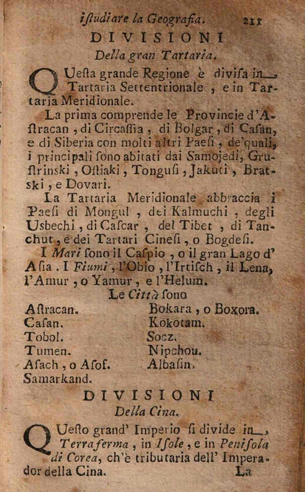
DIVISIONS
Of the great Tartaria.
This large region is divided into Northern Tartaria and Southern Tartaria.
The first includes the Provinces of Astracan, Circassia, Bolgar, Casan, and Siberia with many other countries, of which the main ones are inhabited by the Samojedi, Grustrinski, Ostiaki, Tongusi, Jakuti, Bratski, and Dovari.
Southern Tartaria embraces the countries of Mongul, Kalmuchi, Usbechi, Cascar, Tibet, Tanchut, and the Chinese or Bogdesi.
The Seas are the Caspian, or the great Lake of Asia. The Rivers, the Obio, the Irtisch, the Lena, the Amur, or Yamur, and the Helum.
Cities are
Astracan. Bokara, or Boxora. Casan. Kokotam. Tobol. Socz. Tumen. Nipchou. Asach, or Asof. Albasin. Samarkand.
A little later published "
Introduction to the Mathematical Sciences" by the German
Johann Bernhard Wideburg has a table with the coordinates of major cities in the geography section. In the Great Tartaria section, two cities are listed: Seringua and Kokotam.
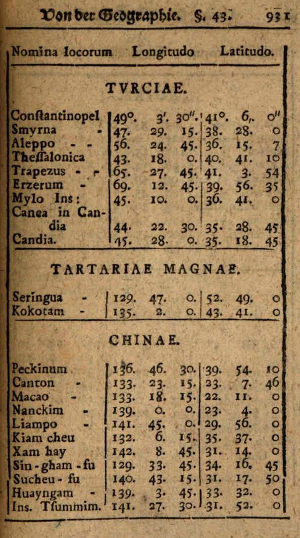
Nowadays little is known about these toponyms, although in the past they were regularly mentioned in geographical literature. The coordinates here use the zero meridian passing through Iceland, i.e. the longitude differs by about 20 degrees from the present one, with a point of reference in London, and the latitude coincides with the present one. For example, in the book the coordinates of Constantinople are: 49°3′30″ and 41°6′0″, while the modern coordinates of Istanbul are 28°57′37″ E and 41°00′36″ N. The difference in longitude is about 20 degrees and 6 minutes and the difference in latitude is about 6 minutes. Similarly, it is possible to find out where these major cities of Tartaria were about 300 years ago.
The current coordinates are 109°47'0" E. 52°49'0" N, corresponding to 129°47'0" | 52°49'0" now, are the mountains of the Republic of Buryatia, the
Turka River basin, there are no settlements within tens of kilometres; to the south-west is
Ulan-Ude, to the west
Baikal, and to the north the village and former town,
Barguzin.
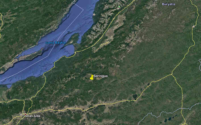
It is possible that the disappearance of any trace of this town is connected with the
powerful earthquakes which took place in the region about 200 years ago. During one of them the inhabited villages went under water and the
Proval Bay was formed.
The current coordinates are 115°2'0" E. 43°41'0" N, corresponding to 135°2'00"| 43°41'0" now, is the
Abag Banner (county) of Xilin Gol League in Inner Mongolia, in China. Most likely, this toponym corresponds to the present-day capital of Inner Mongolia, Hohhot, which is situated 400 km south of these coordinates. As the Wikipedia specifies: "The name has also been variously romanized as Kokotan, Kokutan, Kuku-hoton, Huhohaot'e, Huhehot, Huhot, or Köke qota."
Fyodor Isakovich Baykov, a Russian ambassador who visited China some 350 years ago, described visiting Kokokotan. He described this city as Chinese, stating that it was inhabited by Tibetans (Tybeans), who spoke the Mungal language. Baykov himself was sent to
Bogdykhan (Baldykhan) in Peking, upon reaching the city he refused to perform the humiliating prostration rites. It should be specified, that in Russian Baykov's writings are publicly
available only in a bicentennial edition by
Nikolai Novikov.
It may be added that last year Indiana University published a book titled "
Tatar Empire: Kazan's Muslims and the Making of Imperial Russia" by Professor of History Danielle Ross. In it, Danielle Ross links the history of the Russian imperial project with the history of Russian Muslims, exploring the Kazan Tatars as participants in the building of the Russian Empire.
I suggest looking at a comparative chart of
references to the Mongol and Tartar empires in English:
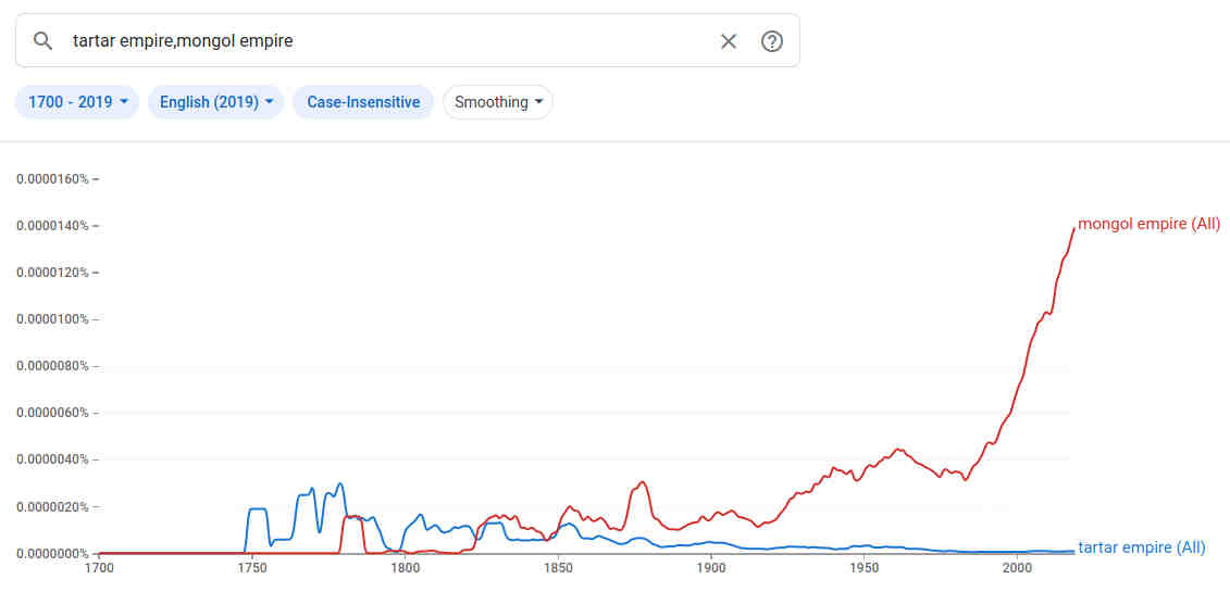
Now almost nothing is known about the former Tartar empire, perhaps the modern notion of
Tatar tribal confederation is closely connected with it. But in the modern version of history, Tamerlane was not the emperor of the Tartars, as previously thought, but he was the founder of the Perso-Turkic-Mongol
Timurid Empire.
#
asia #
catastrophism #
book #
empire #
geography #
maps #
mongol #
past #
revision #
stan #
tartaria #
tartarian #
tartars #
tatarstan #
timespace #
turkic
