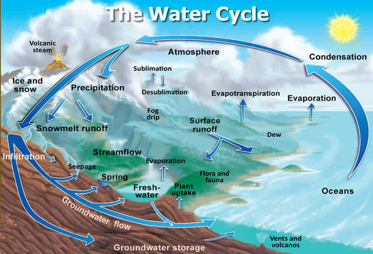
The conventional view is that all water on the planet is involved in the "
Water cycle", and the coastline that typical for today's maps has been the sake for millennia. And a few hundred million years ago the once united continent of
Pangaea split into modern pieces (the "
continental drift" theory). These permanental-cyclical models are instilled in the school system and form the basis of most of humanity's views on nature and the Earth.
Согласно общепринятому взгляду, вся вода на планете участвует в "
круговороте воды", а береговая линия, характерная для сегодняшних карт - была таковой многие тысячелетия, и лишь несколько сотен миллионов лет назад некогда единый континент
Пангея раскололся на современные куски (теория "
дрейфа материков"). Эти перманентно-циклические модели прививаются школьной системой образования, и формируют основу взглядов большинства человечества на окружающую природу и Землю.
Meanwhile, there are some objects on the planet that do not fit well into these conventional models. For example, a river starts at the top of this mountain in Dagestan. Water flows with heavy stream from the rocky ground of the mountain, rather than out of the glacier (as is usual to represent the origin of mountain rivers).
https://www.youtube.com/watch?v=kQJtfXg3sagМежду тем, на планете существую некоторые объекты, плохо укладывающиеся в эти общепринятые модели. Например, из вершины этой горы в Дагестане начинается река. При этом вода сильным потоком бьёт из скалистого грунта горы, а не вытекает из ледника (как обычно принято представлять происхождение горных рек).
A similar source of a mountain river in Chechnya.
https://www.youtube.com/watch?v=Q5hnH6vk4d8Аналогичный исток горной реки в Чечне.
From a rocky hill in Turkey there are many water springs, giving rise to a river.
https://www.youtube.com/watch?v=qohU2GG2sx8Из скалистого холма в Турции бъёт множество родников, давая начало реке.
Similarly, water flows from Uluru Rock, Australia.
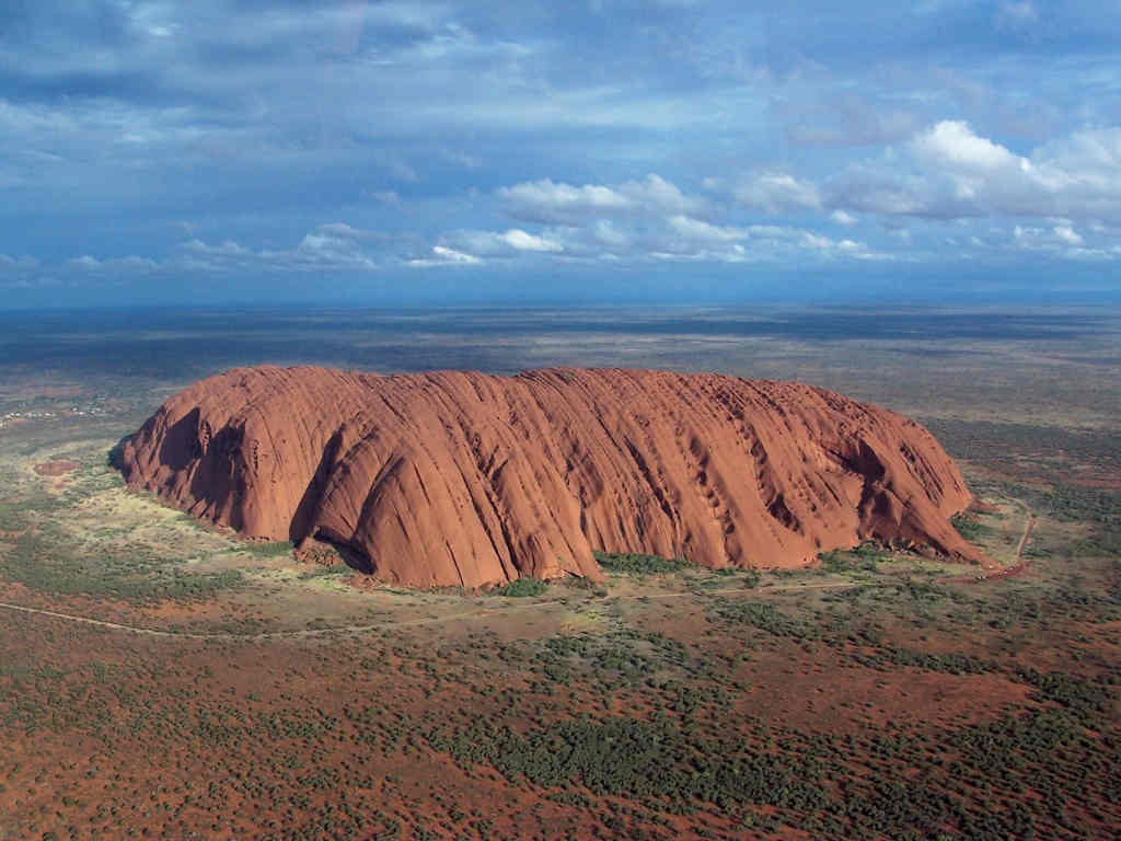
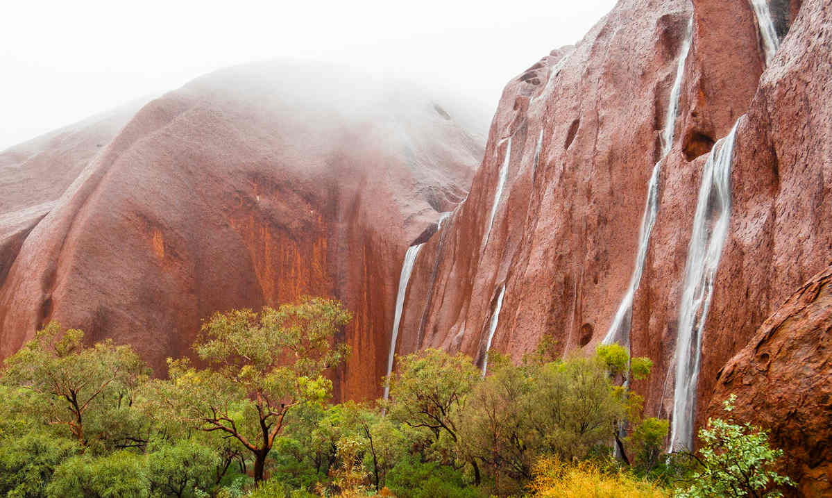
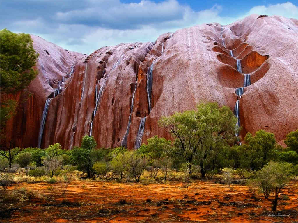
Аналогичным образом вода течёт из скалы Улуру, Австралия.
Source/источник:
 https://sibved.livejournal.com/309956.html https://sibved.livejournal.com/311552.html
It is difficult to explain the origin and force of water flow pressure of such objects, resorting only to generally accepted models. Meanwhile, there are a number of
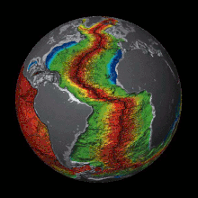
fringe scientific models of the "
expanding Earth", otherwise representing the origin of continents and coastlines.
Сложно объяснить происхождение и силу давления потока воды на подобных объектах, прибегая лишь к общепринятым моделям. Между тем, существует ряд
маргинальных научных моделей "
расширяющейся Земли", иначе представляющих происхождение континентов и береговых линий.
One of the varieties of such models is the so-called model of the "
Primordial Hydride Earth", described by
geologist Vladimir Larin, represents the core of the planet consisting of hydrogen compounds of metals, which during decay emit large amounts of hydrogen from the core, which, in turn, in contact with oxygen from the Earth's crust - gives birth to water. In the areas of riftogenesis (especially in young mountain ranges) this is noticeably the brightest.
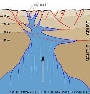
Одна из разновидностей подобных моделей - это так называемая модель "
изначально гидридной Земли", описанная
геологом Владимиром Лариным, представляет ядро планеты состоящим из водородистых соединений металлов, которые при распаде выделяют большие количества водорода из ядра, который, в свою очередь, при контакте с кислородом из земной коры - даёт рождение воде. В областях рифтогенеза (особенно в молодых горных массивах) это заметно наиболее ярко.
#
earth #
expandingearth #
fringe_science #
geology #
growingearth #
hydrogen #
model #
nature #
planet #
revision #
water #
science